Fire Weather Index Data for the Town of Minden, Montgomery County, NY


The following is FWI Data from the Hessville, NY Indian Trail Weather Station
Last updated @ 5/31/2023 1:02:49 PM Eastern Time
This information has been gathered from a Private Weather Station since 5/20/2016
Located at Lat: 42.8643 Long: -74.7214 Alt: 1041 ft ASL in Hessville, NY U.S.A.
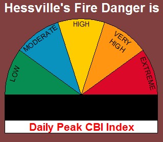
Chandler Burning Index
Index may update throughout the day as Peak conditions intensify
| Peak Time: N/A hrs | |||||||||||||||
|---|---|---|---|---|---|---|---|---|---|---|---|---|---|---|---|
|
0 consecutive days of rain (Last 24 hours: 0.00 in) 2 days since last rainfall |
|||||||||||||||
|---|---|---|---|---|---|---|---|---|---|---|---|---|---|---|---|
Fire Weather Analysis Graphs
The graphs below are calculated using recent weather data observations
and offer an overview of the fire weather conditions for SW Montgomery County.
Updated daily at 13:02 hrs DLST except for the CBI which is updated every 15 minutes
after the initial midday reading until the peak temperature is reached.
Use both the CBI DC and FWI DC classifications to estimate the daily fire danger.
Always check official source's when comparing information obtained from the internet.
| Date | Temp ºF | Humidity % | Wind Speed mph | Rainfall in | FFMC | DMC | DC | ISI | BUI | CBI | CBI DC | FWI | FWI DC | FFDI | Peak Wind mph |
|---|---|---|---|---|---|---|---|---|---|---|---|---|---|---|---|
| 5/5/2023 | --- | --- | --- | --- | 74.1 | 26 | 253 | --- | --- | --- | --- | --- | --- | --- | --- |
| 5/4/2023 | --- | --- | --- | --- | 74.1 | 26 | 253 | --- | --- | --- | --- | --- | --- | --- | --- |
| 5/3/2023 | --- | --- | --- | --- | 74.1 | 26 | 253 | --- | --- | --- | --- | --- | --- | --- | --- |
| 5/2/2023 | --- | --- | --- | --- | 74.1 | 26 | 253 | --- | --- | --- | --- | --- | --- | --- | --- |
| 5/1/2023 | --- | --- | --- | --- | 74.1 | 26 | 253 | --- | --- | --- | --- | --- | --- | --- | --- |
| 4/30/2023 | --- | --- | --- | --- | 74.1 | 26 | 253 | --- | --- | --- | --- | --- | --- | --- | --- |
| 4/29/2023 | --- | --- | --- | --- | 74.1 | 26 | 253 | --- | --- | --- | --- | --- | --- | --- | --- |
| 4/28/2023 | --- | --- | --- | --- | 74.1 | 26 | 253 | --- | --- | --- | --- | --- | --- | --- | --- |
| 4/27/2023 | --- | --- | --- | --- | 74.1 | 26 | 253 | --- | --- | --- | --- | --- | --- | --- | --- |
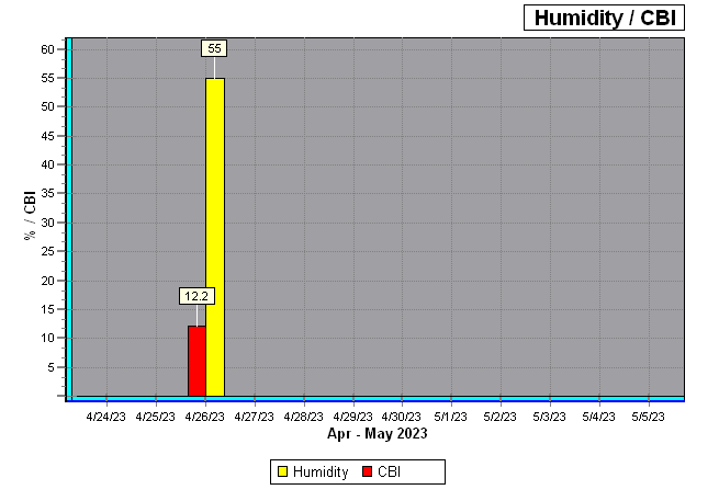
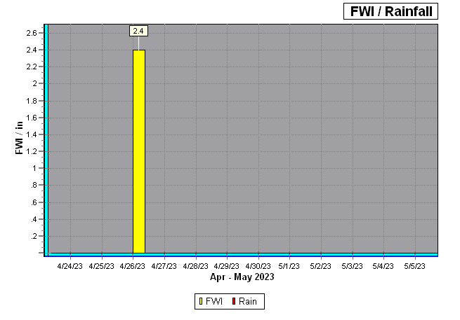
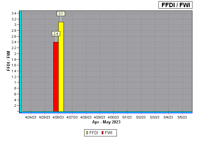
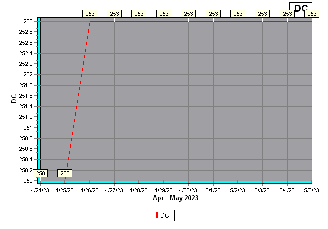
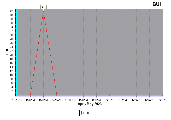
| 4/26/2023 | 54.0 | 55 | 4.0 | 0.00 | 74.1 | 26 | 253 | 1.0 | 42 | 12.2 | LOW | 2.4 | LOW | 3.1 | 4.0 |
| 4/25/2023 | --- | --- | --- | --- | 60.0 | 25 | 250 | --- | --- | --- | --- | --- | --- | --- | --- |
| 4/24/2023 | --- | --- | --- | --- | 60.0 | 25 | 250 | --- | --- | --- | --- | --- | --- | --- | --- |
| 4/23/2023 | --- | --- | --- | --- | 60.0 | 25 | 250 | --- | --- | --- | --- | --- | --- | --- | --- |
| 4/22/2023 | --- | --- | --- | --- | 60.0 | 25 | 250 | --- | --- | --- | --- | --- | --- | --- | --- |
| Statistic data for 2023 Rain Days: 0 Drought Days: 1 |
|||||||||||||||
|---|---|---|---|---|---|---|---|---|---|---|---|---|---|---|---|
| Stat | FFMC | DMC | DC | ISI | BUI | CBI | FWI | ||||||||
| HIGHS | 74.1 4/26/2023 |
26 4/26/2023 |
253 4/26/2023 |
1.0 4/26/2023 |
42 4/26/2023 |
12.2 4/26/2023 |
2.4 4/26/2023 | ||||||||
| LOWS | 74.1 4/26/2023 |
26 4/26/2023 |
253 4/26/2023 |
1.0 4/26/2023 |
42 4/26/2023 |
12.2 4/26/2023 |
2.4 4/26/2023 | ||||||||
| Statistic data since records began on 5/20/2016 | |||||||||||||||
|---|---|---|---|---|---|---|---|---|---|---|---|---|---|---|---|
| Stat | FFMC | DMC | DC | ISI | BUI | CBI | FWI | ||||||||
| HIGHS | 91.6 4/24/2018 |
50 4/26/2023 |
365 7/30/2016 |
32.3 6/16/2020 |
72 6/26/2016 |
74.9 4/24/2018 |
49.3 5/29/2020 | ||||||||
| LOWS | 1.5 11/6/2018 |
0 5/5/2021 |
0 11/30/2018 |
0.0 7/18/2022 |
0 5/5/2021 |
-2.7 12/13/2018 |
0.0 7/18/2022 | ||||||||
Historical Graphic Displays
|
Chandler Burning Index
The Chandler Burning Index (CBI) uses the air temperature, relative humidity, 10 minute average wind and the previous 24 hours of rainfall to calculate a numerical index of fire danger. That number is then equated to the Fire Danger severity of either extreme, very high, high, moderate, or low. It's based solely on weather conditions, with no adjustment for fuel moisture. |
|
Fire Weather Index
The Fire Weather Index (FWI) is based on weather readings taken at noon standard time and rates fire danger at the mid afternoon peak from 2:00 4:00 pm. To interpret the system, the three fuel moisture codes and the three behaviour indices need to be understood. Each code and index is a numerical rating related to likely fire behaviour. The scales start at zero, and except for the Fine Fuel Moisture Code which has a maximum of 99, all are open-ended. Low ratings indicate high moisture content, and ratings rise as moisture content decreases. Ratings rise as fire weather becomes more severe. Weather readings required are: The Fire Weather Index has six components: Three Fuel Moisture Codes: Three Fire Behaviour Indices: |
|
Drought Code
The DC is a numerical rating of the moisture content of deep, compact, organic layers. It is a useful indicator of seasonal drought and shows the likelihood of fire involving the deep duff layers and large logs. A long period of dry weather (the system uses 52 days) is needed to dry out these fuels and affect the Drought Code. A DC rating of 200 is high, and 300 or more is extreme indicating that fire will involve deep sub-surface and heavy fuels. Burning off should not be permitted when the DC rating is above 300. |
|
Build Up Index
The Build Up Index (BUI) shows the amount of fuel available for combustion, indicating how the fire will develop after initial spread. It is calculated from the Duff Moisture Code and the Drought Code. The BUI scale starts at zero and is open-ended. A rating above 34 is high, above 77 is extreme. |
|
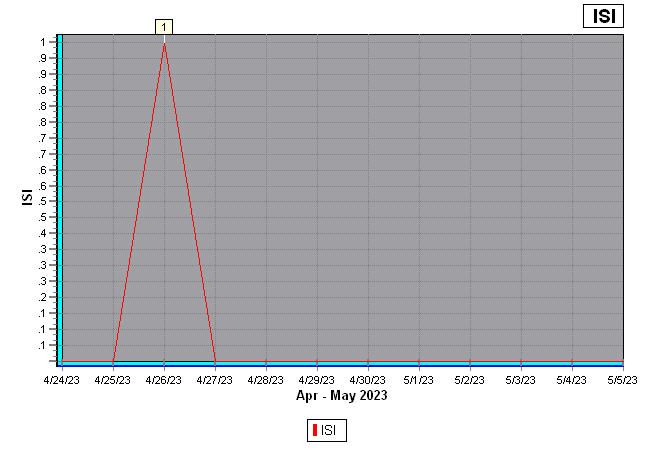
Initial Spread Index
The Initial Spread Index (ISI) indicates the rate fire will spread in its early stages. It is calculated from the FFMC rating and the wind factor. The open-ended ISI scale starts at zero and a rating of 10 indicates high rate of spread shortly after ignition. A rating of 19 or more indicates extremely rapid rate of spread. |
|
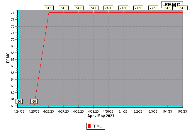
Fine Fuel Moisture Code
The Fine Fuel Moisture Code (FFMC) is a numerical rating of the moisture content of surface litter and other cured fine fuels. It shows the relative ease of ignition and flammability of fine fuels. The moisture content of fine fuels is very sensitive to the weather. Even a day of rain, or of fine and windy weather, will significantly affect the FFMC rating. The system uses a time lag of two-thirds of a day to accurately measure the moisture content in fine fuels. The FFMC rating is on a scale of 0 to 99. Any figure above 70 is high, and above 90 is extreme. |
|
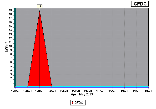
Grass Fire Danger Code
The Grass Fire Danger Code (GFD) is based on predicted generated "fire intensity (kw/m²)" in grass type vegetation (dry grass, tussock). This code denotes how difficult it would be to control a fire in this vegetation type should one start. |
|
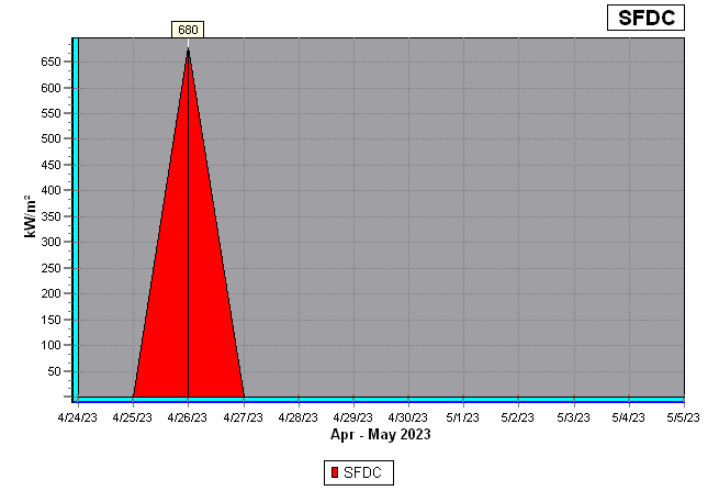
Scrub Fire Danger Code
The Scrub Fire Danger Code (SFDC) is based on predicted generated "fire intensity (kw/m²)" in flammable scrub type vegetation (tea tree, broom, gorse, manuka). This code denotes how difficult it would be to control a fire in this vegetation type should one start. |
|
Forest Fire Danger Code
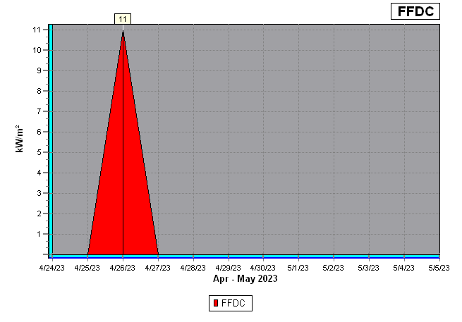
The Forest Fire Danger Code (GFFDC) is based on predicted generated "fire intensity (kw/m²)" in grass type vegetation (dry grass, tussock). This code denotes how difficult it would be to control a fire in this vegetation type should one start. |



 Scan Me With Your Phone's Bar Code Reader App


