Select NOAA-NWS Forecast Office Text Products
(Product availability varies with seasons, forecast office, and weather.)
Hazardous Weather Outlook for Albany, NY
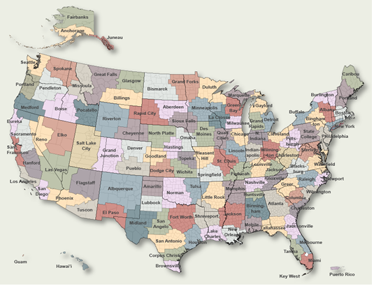
To Select Another NWS Office Click on Map or Choose from List
![]() |
Select Forecast Office: | Select Product: |
789 FLUS41 KALY 110833 HWOALY Hazardous Weather Outlook National Weather Service Albany NY 433 AM EDT Fri Apr 11 2025 CTZ001-013-NYZ032-033-038>043-047>054-059>061-064>066-082>084- VTZ013>015-121100- Northern Litchfield-Southern Litchfield-Northern Herkimer-Hamilton- Southern Herkimer-Southern Fulton-Montgomery-Northern Saratoga- Northern Warren-Northern Washington-Schoharie-Western Schenectady- Eastern Schenectady-Southern Saratoga-Western Albany-Eastern Albany- Western Rensselaer-Eastern Rensselaer-Eastern Greene- Western Columbia-Eastern Columbia-Eastern Ulster-Western Dutchess- Eastern Dutchess-Northern Fulton-Southeast Warren- Southern Washington-Bennington-Western Windham-Eastern Windham- 433 AM EDT Fri Apr 11 2025 This Hazardous Weather Outlook is for northwestern Connecticut, eastern New York and southern Vermont. .DAY ONE...Today and tonight. Another storm system will bring some accumulating wet snow late tonight into Saturday. The southern Greens of southern Vermont and the Litchfield Hills of northwest Connecticut may receive a light to moderate snow accumulation with some sleet or freezing rain mixing in briefly. Winter Weather Advisories may be necessary, if confidence increases in the snow amounts or wintry mixed precipitation. Lighter snow amounts will likely occur on the grassy surfaces in the valleys. .DAYS TWO THROUGH SEVEN...Saturday through Thursday. A storm system will bring some accumulating wet snow into Saturday. The southern Greens of southern Vermont and the Litchfield Hills of northwest Connecticut may receive a light to moderate snow accumulation with some sleet or freezing rain mixing in briefly. Winter Weather Advisories may be necessary, if confidence increases in the snow amounts or wintry mixed precipitation. Lighter snow amounts will likely occur on the grassy surfaces in the valleys. .SPOTTER INFORMATION STATEMENT... Weather spotters are encouraged to report winter precipitation amounts to the National Weather Service in Albany New York. $$ MAZ001-025-NYZ058-063-121100- Northern Berkshire-Southern Berkshire-Western Greene-Western Ulster- 433 AM EDT Fri Apr 11 2025 ...WINTER WEATHER ADVISORY IN EFFECT FROM MIDNIGHT TONIGHT TO 2 PM EDT SATURDAY... This Hazardous Weather Outlook is for Berkshires western Massachusetts and the eastern Catskills of western Greene and western Ulster Counties in eastern New York. .DAY ONE...Today and tonight. Please listen to NOAA Weather Radio or go to weather.gov on the Internet for more information about the following hazards. Winter Weather Advisory. .DAYS TWO THROUGH SEVEN...Saturday through Thursday. Please listen to NOAA Weather Radio or go to weather.gov on the Internet for more information about the following hazards. Winter Weather Advisory. .SPOTTER INFORMATION STATEMENT... Weather spotters are encouraged to report winter precipitation amounts to the National Weather Service in Albany New York. $$ |
Previous Hazardous Weather Outlooks may be found at
NWS Albany, NY (ALY) Office Hazardous Weather Outlooks.
(Click 'Previous Version' there to view past versions successively.
Some may differ only in time posted.)
Products Courtesy of NOAA-NWS
NWS Information Parsing Script by Ken True at Saratoga Weather - WFO and Products Scripts by SE Lincoln Weather.
Mapping by Curly at Michiana Weather and by Tom at My Mishawaka Weather.